

By Tabitha Evans Moore
EDITOR & PUBLISHER
In 2021, then President Joe Biden recognized October 12 as Indigenous People’s Day via presidential proclamations. Though not a federally-recognized holiday nor officially recognized by the State of Tennessee, the history of Native Americans in our region is fascinating.
Ask most people in Moore County which tribe lived here, and you’ll likely hear “the Cherokee.” The real answer is more complicated, and in some ways more interesting. For roughly a century before the first white families built cabins along Mulberry Creek, no tribe kept a town in what is now Moore County. That wasn’t because the land was empty. It was because it was too valuable for any one nation to hold alone.
Long before that, it was home. And the way it stopped being Native land, through a pair of treaties and a boundary line drawn in the wrong place, is a story that runs straight through Lynchburg.
10,000 YEARS ON THE ELK
Mulberry Creek drains into the Elk River, and the Elk River valley holds some of the deepest human history in this part of Tennessee. When the Tennessee Valley Authority surveyed the shoreline of what would become Tims Ford Lake in the early 1970s, archaeologists recorded dozens of sites, with spear points and tools dating from the Paleoindian period, the last stretch of the Ice Age, through the Archaic and into the Woodland era. A 1973 survey of the Upper Elk River Basin added dozens more.
About 20 miles to the northeast, the people of this region left one of the most remarkable monuments in the South. Old Stone Fort, outside Manchester, isn’t a fort at all. It is a ceremonial enclosure, a wall of stone and earth around a 50-acre plateau where the Duck and Little Duck rivers meet. It was built and used between roughly A.D. 80 and 550, and its entrance lines up with sunrise on the summer solstice. Archaeologists working there in the late 1960s found five villages of the same period within 20 miles of the site. The people who gathered there lived in this region, and very likely hunted, fished and traveled the creeks that run through Moore County today.
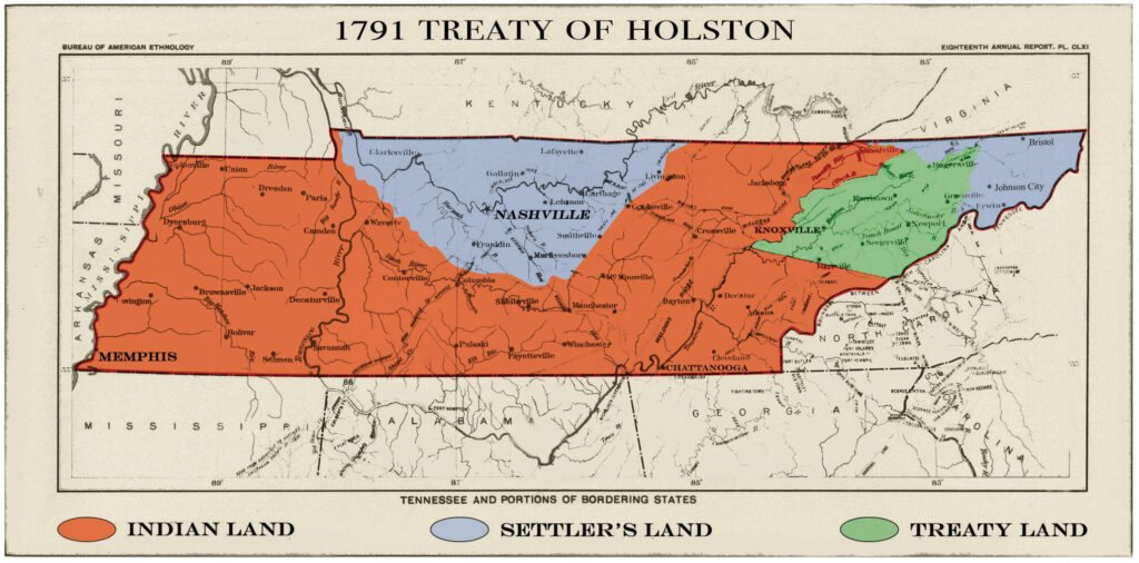
By the time Europeans began writing about Middle Tennessee, the region had become something different: a shared hunting ground. The Shawnee had settled along the Cumberland River in the 1600s, but around 1714 the Cherokee and Chickasaw allied and drove them out. After that, according to state histories, Middle Tennessee had no permanent Native towns.
It was far from empty. Cherokee, Chickasaw, Creek and Choctaw hunters, and Shawnee and other northern nations, came here for months at a time for the deer, elk, bison and bear that filled the canebrakes. The Cherokee and Chickasaw both claimed the land, and their claims overlapped right across this part of the state. When the first settlers reached what is now Moore County, the county’s 1887 history recorded, bears, wolves and deer were still abundant.
TWO TREATIES AND A MISTAKE
The land that would become Moore County passed out of Native hands in a span of about two years.
In October 1805, the Cherokee ceded their claims north of the Duck River. That same year, the Chickasaw ceded a large tract of Middle Tennessee that expressly included all the waters of the Elk River. Then, in January 1806, Cherokee leaders signed the Treaty of Washington, giving up their claim to the country between the Duck River and the Tennessee River. In exchange, the United States agreed to pay $10,000, build a gristmill, provide a cotton gin and pay the Cherokee chief Black Fox $100 a year. The Creek, who also claimed part of the region, were paid $14,000 for their interest.
But there was a problem. The treaty’s eastern boundary was drawn to the headwaters of the Duck River, because everyone at the table assumed the Duck rose farther east than the Elk. It doesn’t. The upper Elk River basin, the watershed that includes Mulberry Creek, was left outside the line.
Settlers didn’t wait for Washington to sort it out. They poured into the upper Elk country while the federal government scrambled to fix its error. The Cherokee leader Doublehead, who had signed the 1806 treaty, was killed in August 1807 by Major Ridge and other Cherokee, angered by his land dealings. On Sept. 11, 1807, an “Elucidation” of the treaty was signed, and the upper Elk River watershed formally became United States territory.
The record of Moore County’s first white families tracks almost exactly with those treaties. The 1887 Goodspeed history lists a settler named Prosser arriving in 1806, William Spencer in 1808 and Michael Tipps in 1813. Within a decade of the Elucidation, the hunting ground had become farmland.
THE TRAIL OF TEARS, JUST OVER THE COUNTY LINE
Thirty years later, the Cherokee who remained in their eastern homeland were forced west. One detachment of about 650 to 700 people, led by John A. Bell, left Fort Cass in Charleston, Tenn., on Oct. 11, 1838. They crossed the Cumberland Plateau through Monteagle, Sewanee and Cowan, then went through Winchester and west along the route of today’s Highway 64 to Fayetteville and on toward Memphis.
That route passed just south of the Moore County line, through Franklin and Lincoln counties. It is one of 17 detachments commemorated by the Trail of Tears National Historic Trail.
Bell’s group was made up largely of the “Treaty Party,” Cherokee who supported the 1835 Treaty of New Echota that gave up the nation’s remaining eastern land. Among that treaty’s signers was Major Ridge, the same man who had killed Doublehead three decades earlier for selling Cherokee land.
A historical marker for the Bell Route in Monteagle ends with a line worth remembering today: in spite of removal, many Cherokee remain in Tennessee. In the 2020 census, a small number of Moore County residents identified as Native American.
No tribe built its towns in the hollows around Lynchburg in the centuries just before settlement. But Native people walked this ground for more than ten thousand years, built one of the South’s great ceremonial sites an afternoon’s walk away, and fought over, hunted and finally signed away the land the county now sits on. The cabins, the mills and eventually the distillery came after.
Old Stone Fort State Archaeological Park, Manchester. Trail of Tears National Historic Trail (National Park Service). Tennessee Division of Archaeology, Nashville. Cherokee Nation, Eastern Band of Cherokee Indians, United Keetoowah Band and Chickasaw Nation cultural and historic preservation offices. •
About the Lynchburg Times: The Lynchburg Times is Moore County’s locally owned, independent news source and the only local media source owned by a Lynchburg native and one of the few Tennessee newsrooms owned by a woman. Our reporting is supported by readers, small business partners, and underwriters who believe community journalism matters. If this story was valuable to you, consider becoming a supporter at lynchburgtimes.com.
Leave a Reply
You must be logged in to post a comment.